Media Radar Observations API
Rain Radar Images
These calls are used to access the list of available rain radar images. The images consist of the layers which have to be composited in the web browser or mobile app.
The images have the following layers:
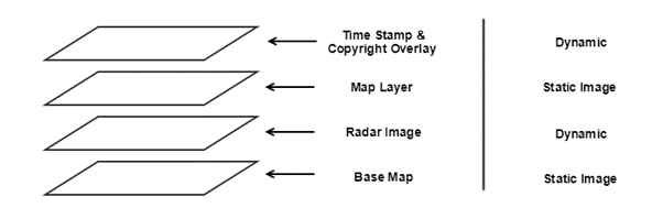
The time stamp and radar images are dynamic and change every time a new radar scan is made available. The base map and map layers are static. The same image can be used for every image in the animation.
There is a different “Time Stamp & Copyright Overlay” image for each radar image in the animation. The copyright information must be shown on each radar image retrieved through the Weather API.
The service only holds radar images for 24 hours.
All images are 512x512 pixels in size.
1 By Area:
Description: This call is used to get a list of available composite images for a specific area. Currently the only area supported is ‘national’ which shows a national view of Australia; further releases will include state level views.
See Additional Parameters below for additional filtering options.
API Call:
GET /countries/{countryCode}/observations/radarImages/areas/{areaCode}Parameters:
| Parameter | Example | Description |
|---|---|---|
| countryCode | au | This is the short code of the country that the weather information relates to. Available codes are: au – Australia This parameter is Mandatory. |
| areaCode | national | This is the name of the area. Currently only national is supported. This parameter is Mandatory. |
Example:
This example shows a request to get a list of composite images showing the national view of Australia.
To retrieve the images a separate call must be made to the asset service.
GET /countries/au/observations/radarImages/areas/nationalAPI Response:
[
    {
        "aus":{
            "basemaps":[
                {
                    "plain":"/assets/au/radar/basemaps/IDR00004/aus/plain.jpg"
                }
            ],
            "layers":[
                {
                    "cities":"/assets/au/radar/layers/IDR00004/aus/cities.png"
                }
            ],
            "images":[
                {
                    "image":"/assets/au/radar/IDR00004/aus/20180117T021800Z.png",
                    "label":"Wed 17 Jan, 13:18"
                },
                {
                    "image":"/assets/au/radar/IDR00004/aus/20180117T022800Z.png",
                    "label":"Wed 17 Jan, 13:28"
                },
                {
                    "image":"/assets/au/radar/IDR00004/aus/20180117T023800Z.png",
                    "label":"Wed 17 Jan, 13:38"
                },
                {
                    "image":"/assets/au/radar/IDR00004/aus/20180117T024800Z.png",
                    "label":"Wed 17 Jan, 13:48"
                },
                {
                    "image":"/assets/au/radar/IDR00004/aus/20180117T025800Z.png",
                    "label":"Wed 17 Jan, 13:58"
                }
            ],
            "timestamp-overlays":[
                {
                    "overlay":"/assets/au/radar/timestamp-overlays/IDR00004/aus/20180117T021800Z.png"
                },
                {
                    "overlay":"/assets/au/radar/timestamp-overlays/IDR00004/aus/20180117T022800Z.png"
                },
                {
                    "overlay":"/assets/au/radar/timestamp-overlays/IDR00004/aus/20180117T023800Z.png"
                },
                {
                    "overlay":"/assets/au/radar/timestamp-overlays/IDR00004/aus/20180117T024800Z.png"
                },
                {
                    "overlay":"/assets/au/radar/timestamp-overlays/IDR00004/aus/20180117T025800Z.png"
                }
            ]
        }
    }
]
Data fields:
| Field Name | Data Type | Description |
|---|---|---|
| aus | object | The radius of the radar area, in this case national. |
| basemaps | array | Lists links to base map images. |
| layers | array | Lists links to map layer images. |
| images | array | Lists links to radar images. |
| timestamp-overlays | array | Lists links to time stamp and copyright overlay images. |
2 By Radar Station:
Description: This call is used to get a list of available images for a specific rain radar station.
See Additional Parameters below for additional filtering options.
API Call:
GET /countries/{countryCode}/observations/radarImages/radarStations/{stationID}?radius={radiusCode}Parameters:
| Parameter | Example | Description |
|---|---|---|
| countryCode | au | This is the short code of the country that the weather information relates to. Available codes are: au – Australia This parameter is Mandatory. |
| stationID | IDR40 | This is the unique ID of the individual radar station. This parameter is Mandatory. |
| radius | 128 | This is the radius of the radar scan. It is used as a proxy for resolution. The smaller the radius the higher the resolution of the radar image. Radius is measured in Km. There are two values available 128 and 512. This parameter is Optional. If the radius parameter is not specified, lists of images for all radii are returned. |
Example:
This example shows a request to get a list of high resolution images for Canberra.
To retrieve the images a separate call must be made to the Asset Service.
GET /countries/au/observations/radarImages/radarStations/IDR40API Response:
[
    {
        "128k":{
            "basemaps":[
                {
                    "plain":"/assets/au/radar/basemaps/IDR40/128k/plain.jpg"
                }
            ],
            "layers":[
                {
                    "cities":"/assets/au/radar/layers/IDR40/128k/cities.png"
                }
            ],
            "images":[
                {
                    "image":"/assets/au/radar/IDR40/128k/20180117T022400Z.png",
                    "label":"Wed 17 Jan, 13:24"
                },
                {
                    "image":"/assets/au/radar/IDR40/128k/20180117T023000Z.png",
                    "label":"Wed 17 Jan, 13:30"
                },
                {
                    "image":"/assets/au/radar/IDR40/128k/20180117T023600Z.png",
                    "label":"Wed 17 Jan, 13:36"
                },
                {
                    "image":"/assets/au/radar/IDR40/128k/20180117T024200Z.png",
                    "label":"Wed 17 Jan, 13:42"
                },
                {
                    "image":"/assets/au/radar/IDR40/128k/20180117T024800Z.png",
                    "label":"Wed 17 Jan, 13:48"
                },
                {
                    "image":"/assets/au/radar/IDR40/128k/20180117T025400Z.png",
                    "label":"Wed 17 Jan, 13:54"
                },
                {
                    "image":"/assets/au/radar/IDR40/128k/20180117T030000Z.png",
                    "label":"Wed 17 Jan, 14:00"
                },
                {
                    "image":"/assets/au/radar/IDR40/128k/20180117T030600Z.png",
                    "label":"Wed 17 Jan, 14:06"
                }
            ],
            "timestamp-overlays":[
                {
                    "overlay":"/assets/au/radar/timestamp-overlays/IDR40/128k/20180117T022400Z.png"
                },
                {
                    "overlay":"/assets/au/radar/timestamp-overlays/IDR40/128k/20180117T023000Z.png"
                },
                {
                    "overlay":"/assets/au/radar/timestamp-overlays/IDR40/128k/20180117T023600Z.png"
                },
                {
                    "overlay":"/assets/au/radar/timestamp-overlays/IDR40/128k/20180117T024200Z.png"
                },
                {
                    "overlay":"/assets/au/radar/timestamp-overlays/IDR40/128k/20180117T024800Z.png"
                },
                {
                    "overlay":"/assets/au/radar/timestamp-overlays/IDR40/128k/20180117T025400Z.png"
                },
                {
                    "overlay":"/assets/au/radar/timestamp-overlays/IDR40/128k/20180117T030000Z.png"
                },
                {
                    "overlay":"/assets/au/radar/timestamp-overlays/IDR40/128k/20180117T030600Z.png"
                }
            ]
        }
    },
    {
        "512k":{
            "basemaps":[
                {
                    "plain":"/assets/au/radar/basemaps/IDR40/512k/plain.jpg"
                }
            ],
            "layers":[
                {
                    "cities":"/assets/au/radar/layers/IDR40/512k/cities.png"
                }
            ],
            "images":[
                {
                    "image":"/assets/au/radar/IDR40/512k/20180117T022300Z.png",
                    "label":"Wed 17 Jan, 13:23"
                },
                {
                    "image":"/assets/au/radar/IDR40/512k/20180117T022900Z.png",
                    "label":"Wed 17 Jan, 13:29"
                },
                {
                    "image":"/assets/au/radar/IDR40/512k/20180117T023500Z.png",
                    "label":"Wed 17 Jan, 13:35"
                },
                {
                    "image":"/assets/au/radar/IDR40/512k/20180117T024100Z.png",
                    "label":"Wed 17 Jan, 13:41"
                },
                {
                    "image":"/assets/au/radar/IDR40/512k/20180117T024700Z.png",
                    "label":"Wed 17 Jan, 13:47"
                },
                {
                    "image":"/assets/au/radar/IDR40/512k/20180117T025300Z.png",
                    "label":"Wed 17 Jan, 13:53"
                },
                {
                    "image":"/assets/au/radar/IDR40/512k/20180117T025900Z.png",
                    "label":"Wed 17 Jan, 13:59"
                },
                {
                    "image":"/assets/au/radar/IDR40/512k/20180117T030500Z.png",
                    "label":"Wed 17 Jan, 14:05"
                },
                {
                    "image":"/assets/au/radar/IDR40/512k/20180117T031100Z.png",
                    "label":"Wed 17 Jan, 14:11"
                }
            ],
            "timestamp-overlays":[
                {
                    "overlay":"/assets/au/radar/timestamp-overlays/IDR40/512k/20180117T022300Z.png"
                },
                {
                    "overlay":"/assets/au/radar/timestamp-overlays/IDR40/512k/20180117T022900Z.png"
                },
                {
                    "overlay":"/assets/au/radar/timestamp-overlays/IDR40/512k/20180117T023500Z.png"
                },
                {
                    "overlay":"/assets/au/radar/timestamp-overlays/IDR40/512k/20180117T024100Z.png"
                },
                {
                    "overlay":"/assets/au/radar/timestamp-overlays/IDR40/512k/20180117T024700Z.png"
                },
                {
                    "overlay":"/assets/au/radar/timestamp-overlays/IDR40/512k/20180117T025300Z.png"
                },
                {
                    "overlay":"/assets/au/radar/timestamp-overlays/IDR40/512k/20180117T025900Z.png"
                },
                {
                    "overlay":"/assets/au/radar/timestamp-overlays/IDR40/512k/20180117T030500Z.png"
                },
                {
                    "overlay":"/assets/au/radar/timestamp-overlays/IDR40/512k/20180117T031100Z.png"
                }
            ]
        }
    }
]
Data fields:
| Field Name | Data Type | Description |
|---|---|---|
| 128K | object | Images with a 128K resolution. |
| 512K | object | Images with a 512K resolution. |
| basemaps | array | Lists links to base map images. |
| layers | array | Lists links to map layer images. |
| images | array | Lists links to radar images. |
| timestamp-overlays | array | Lists links to time stamp and copyright overlay images. |
Additional Parameters
Both the area and radar station calls can optionally have their results filtered by the use of additional parameters. The additional parameters also allow access to previous results.
| Parameter | Example | Description |
|---|---|---|
| period | 4H | The period parameter represents the length of time going backwards from current time. This is case period can only be specified in hours (H). For example, 4H it the last 4 hours or radar images. When period=current is used, the results show only the last radar(s) image(s). The maximum period allowed is 24 hours, that is, period=24H. The default behavior is period=1H |